 Reports from the National Weather Service have indicated an extremely wet and windy weekend, and while we here at Observer Newspaper aren’t meteorologists, take precautions as you travel this weekend. Report below from National Weather Service: http://forecast.weather.gov/showsigwx.php?warnzone=FLZ172&warncounty=FLC011&firewxzone=FLZ172&local_place1=Pompano+Beach+FL&product1=Short+Term+Forecast
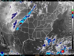
In short, look at the image to the right and the blue and red indicates high levels of rain, wind and moisture headed to South Florida.
THE NATIONAL WEATHER SERVICE IN MIAMI HAS ISSUED A
* FLOOD WATCH FOR A PORTION OF SOUTH FLORIDA...INCLUDING THE
  FOLLOWING AREAS...COASTAL BROWARD...COASTAL MIAMI DADE...
  COASTAL PALM BEACH...FAR SOUTH MIAMI DADE...INLAND BROWARD...
  INLAND MIAMI DADE...INLAND PALM BEACH...METRO BROWARD...METRO
  MIAMI DADE AND METRO PALM BEACH.

* THROUGH SUNDAY EVENING

* PLENTY OF DEEP LAYER MOISTURE SPREADING NORTH OVER THE LOCAL
  AREA WILL LEAD TO A PROLONGED PERIOD OF RAIN THROUGH THE
  WEEKEND. RAINFALL TOTALS ARE EXPECTED TO REACH THE 3 TO 6 INCH
  RANGE THROUGH THIS TIME WITH LOCALLY HIGHER AMOUNTS
  POSSIBLE...ESPECIALLY OVER THE COASTAL AND METRO LOCATIONS.
  RAINFALL TOTALS OVER THE PAST 12 TO 24 HRS HAVE ALREADY REACHED
  THE 1 TO 2.5 INCH RANGE. THESE SIGNIFICANT RAINFALL AMOUNTS
  COULD CAUSE FLOODING OF ROADS AND POOR DRAINAGE AREAS THROUGH
  THIS TIME.

PRECAUTIONARY/PREPAREDNESS ACTIONS...

A FLOOD WATCH MEANS THERE IS A POTENTIAL FOR FLOODING BASED ON
CURRENT FORECASTS.

YOU SHOULD MONITOR LATER FORECASTS AND BE ALERT FOR POSSIBLE
FLOOD WARNINGS. THOSE LIVING IN AREAS PRONE TO FLOODING SHOULD BE
PREPARED TO TAKE ACTION SHOULD FLOODING DEVELOP.


 South Florida from Palm Beach to the Keys is currently under a tornado watch as weather conditions deteriorate across the region. This is not the day to be in the water as water spouts and rip currents are highly likely. A slight risk of tornadoes will be present over much of South Florida late this morning through the afternoon, primarily from the Cape Sable area northward through the Southeast Florida metro areas, with lesser chances over the western half of the peninsula.