

 Due to severe weather and dangerously high surf, the International Fishing Pier closed at 3:30 PM Thursday, Aug. 25. Weather permitting, the pier will re-open Friday morning. The beach is also closed to swimmers. Future updates posted on this website.
Tag Archive | "deerfield beach"
Tags: bad, closed, deerfield beach, fishing pier, hurricane, irene, NOAA, tropical, tropical storm, weather
Deerfield Beach Fishing Pier closed by severe weather
Posted on 25 August 2011 by LeslieM
Tags: broward county, deerfield beach, hurricane, irene, observer, tropical storm
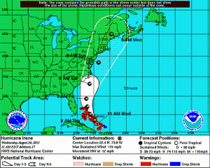
Irene tracks to east, tropical storm watch in effect
Posted on 24 August 2011 by JLusk
 Hurricane Irene, now a category 3 storm, remains steady on the forecast track staying east of Broward. A tropical storm watch is in effect for the Atlantic waters off southeast Florida; however, no tropical storm watches are planned for land areas. Due to the close proximity of Hurricane Irene, marine interests should exercise caution until the storm passes. While a direct impact from Hurricane Irene continues to become less likely, peripheral impacts are expected. Residents should expect gusty winds and showers beginning Thursday morning. There continues to be a 25 percent probability of tropical storm force winds affecting Broward County. Rough surf and beach erosion is expected. Motorists should use caution when traveling the roadways and treat intersections without working signals as four-way stops. Travelers should check with their airline or cruise line for delays and cancellations. The Fort Lauderdale-Hollywood International Airport reports that due to deteriorating conditions in the Caribbean there have been numerous cancellations in and out of the Bahamas today. The Broward County Emergency Operations Center remains at a monitoring level and emergency management officials continue to keep a close watch on Hurricane Irene. Residents should remain vigilant and stay tuned to TV and radio for updates.
Comments Off on Irene tracks to east, tropical storm watch in effect

Tags: Clergy, Clergy Corner, Craig Ezring, deerfield beach, Rabbi
Who, what, where and when
Posted on 24 August 2011 by LeslieM
There was a heavy downpour the other day as we were in the midst of a service at one of the local health centers. At one point, the electricity went out for a minute and, while many people made a joke out of it, others were immediately worried and voiced concerns:
“What if the elevator doesn’t work?”
“What if we don’t get the air-conditioning back on? After all, the temperature is in the 90s outside.”
While the electricity was off, I posed the question if anyone had taken the time recently to thank G-d for the fact that we have an elevator to get up and down to the various floors and if anyone had taken the time (before the power went out) to thank G-d for the air-conditioning system, which keeps the place nice and comfortable in the midst of the brutal heat wave of recent weeks.
Fortunately, the power came back on rather quickly, but, I asked them to think about what they would have done if the power had not come back on. Many said they would stay in their rooms until the power was restored. Well, that might be fine if the power comes back on at some point in the day, but what if the power doesn’t get restored for several days? What then?
And without realizing it, we began an important dialogue on hurricane preparedness. Some of the people at the service have portable oxygen tanks. Others have to be hooked up to a machine three times a week for dialysis, so I had to ask if they knew what they would do and where they would go should a major storm like a hurricane kill all the electric power for a while.
We talked about what to do and we made a list of the many things we are blessed with that we often take for granted, and we thought about how we would survive if we did not have them in our lives.
Many people remembered things that they had read about … what you need to have around in case of a hurricane. Many had even been to seminars about it. People talked about the need to have a flashlight and extra batteries. People talked about the need to have bottled water. People talked about the need to have some food around that is easy to open and requires no refrigeration and no cooking.
The residents came up with just about everything one needed to have in preparation for a major storm and a major power failure. Everyone was listening. Everyone was participating. Everyone was paying attention.
And just before the end of the service, I decided I had a few more questions to ask …
“How many of you have extra water in your house?”
“How many of you have a flashlight and extra batteries?”
“How many of you have bottles of water?”
“How many of you have food that does not require refrigeration or cooking?”
“How many of you know where to go if you need special medical care?”
Amazingly, not one person could answer “yes” to any of these questions. Many said that someone else would take care of it for them, but who?
Hillel asked the question, “If I am not for myself who will be for me? If I am only for myself, what am I? And, if not now, when?”
It is time to prepare. Get what you need so you are covered. Cover for others who are unable to get the supplies they need, and remember, knowing what needs to be done … knowing what supplies you need doesn’t do any good unless you go out and purchase those things. Don’t delay. If not now….when?
Shalom My Friends,
Rabbi Craig H. Ezring
Rabbi Ezring is a Hospice Chaplain and Member of the National Association of Jewish Chaplains. He also provides Professional Pastoral Care Services to a number of health centers in Broward County.
Comments Off on Who, what, where and when
Tags: broward, broward county, deerfield beach, florida, hillsboro beach, hurricane irene, irene, latest information, lighthouse point, nhc, pompano beach, storm track, tropical storm, weather information, where is it going
Irene becomes first hurricane, still generally headed to South Florida
Posted on 22 August 2011 by LeslieM

Comments Off on Irene becomes first hurricane, still generally headed to South Florida

Tags: deerfield beach, forecast track, hillsboro beach, lighthouse point, map, national hurricane center, path, pompano beach, prepare, south florida, tropical storm irene, where is it going
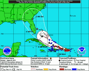
Tropical Storm Irene puts Deerfield Beach, South Florida in the cone again
Posted on 21 August 2011 by LeslieM
From the National Hurricane Center:

Comments Off on Tropical Storm Irene puts Deerfield Beach, South Florida in the cone again
Tags: bank, broward sheriff's office, BSO, crime, deerfield beach, poice, robbed, robbery
Bank robbed in Deerfield Beach
Posted on 18 August 2011 by LeslieM
Just before 2pm today the Chase Bank at 1100 E. Hillsboro Blvd was robbed by an armed suspect. Deputies quickly arrived on scene, gathered detailed information on the suspect and get away vehicle, and arrested him minutes later in the 4200 block of S. Federal Highway.
Comments Off on Bank robbed in Deerfield Beach
Tags: Christian Love Fellowshhip, Clergy, Clergy Corner, deerfield beach, Pastor Tony Guadagnino
Change course
Posted on 18 August 2011 by LeslieM
There might be a path you are traveling down in life that seems good, but the reality is that we may be headed for destruction because we are following ourselves (a man) instead of The Man.
I heard a sermon illustration once about a battleship that appeared to be on a collision course with another ship one foggy evening.
The battleship’s captain radioed to the unknown ship, “Advise you change course 20 degrees to avoid collision.”
Someone on a radio replied, “Advise you change course 20 degrees to avoid collision.”
The battleship’s captain was not amused. He radioed, “I am a ship’s captain. Change course 20 degrees now!”
Then came another reply, “I’m a seaman second-class and I advise you to change course 20 degrees now!”
The captain was furious, “This is a battleship! I order you to change course 20 degrees immediately!”
The seaman radioed back, “I am a lighthouse!”
Have you ever found yourself in a situation where you just don’t want to budge on your position? Everyone is stubborn from time to time, but people who live a lifestyle of stubbornness are dangerous to their relationships with others and with God. When we are overly stubborn with others, we build walls that prevent relationships from growing – and when those walls are high enough, they actually cause relationships to die. In successful relationships, no one has their own way all of the time. Both in friendships and in family relationships, the one who is never willing to “change course” damages those relationships.
NEHEMIAH 9:29
You warned them to return to your Law, but they became proud and obstinate and disobeyed your commands. They did not follow your regulations, by which people will find life if only they obey. They stubbornly turned their backs on you and refused to listen.
NLT
God has been warning us over and over to listen to his word and not to ignore it. If we continue to ignore Him, we will be living with some things much longer than we would like to and possibly forever. When all is well, stop assuming that you had anything to do with it, you stubborn little goat. Stubbornness in our relationship with God works much the same way as stubbornness with friends and family. Being stubborn with God means that we really don’t want to please the Lord, but we want to “call our own shots” and determine our own course in life. God becomes the little pocket genie, “the magic lamp” we rub and ask for favors when we want something for ourselves. When we are stubborn with God, we push his rightful place in our life aside. Being stubborn with God is sin, plain and simple. When refusing to “change course,” we might well find ourselves, much like the battleship captain, on the verge of disaster. We may get what we want, but getting what we want can actually destroy us.
My challenge for you today, in relationships with people and with God, is that you be willing to give and be willing to “change course” if necessary, in order to build your relationships instead of tearing them down. Have you damaged relationships with people or with God by being stubborn? Will you have the courage to ask them for their forgiveness?
Pastor Tony Guadagnino
Christian Love Fellowship Church
Comments Off on Change course
Tags: broward sheriff's office, BSO, burglar, crime, deerfield, deerfield beach, local, news
Three suspects arrested in East Deerfield when alert neighbor calls BSO
Posted on 15 August 2011 by LeslieM
Just after 9:30am this morning BSO deputies responded to the 300 block of SE 8 Avenue after a resident reported seeing three suspects climbing through a neighbor’s window. Deputies quickly arrived on scene and set up a perimeter. Three suspects were quickly captured. The BSO helicopter was also on scene. If you see suspicious activity in your neighborhood call 911 immediately.
Comments Off on Three suspects arrested in East Deerfield when alert neighbor calls BSO

Tags: broward, broward news, broward school board, dave thomas, david thomas, deerfield beach, jennifer gottlieb, school board members resign
Two Broward School Board members resign
Posted on 12 August 2011 by JLusk

Jennifer Gottlieb (At-Large)
First, on Aug. 11, School Board member Dave Thomas of Coral Springs says he is resigning. Now, one day later, it has been confirmed by the School Board that Jennifer Gottlieb (At Large) is also resigning, effective today.
While Thomas’ resignation letter has been officially released to the press, Gottlieb’s has not at this time. Thomas said his decision to leave “is prompted by a recent family medical situation…”
Gottlieb, who went through the Broward School system herself and graduated from Nova High School, was originally elected to the board in 2006.
Any person who leaves the School Board will have to be replaced and that decision will remain in the hands of Governor Rick Scott.

Dave Thomas
Tags: Clergy, Clergy Corner, Craig Ezring, deerfield beach, Insurance, Rabbi, reassurance
Insurance and reassurance
Posted on 11 August 2011 by LeslieM
As I returned home from work the other day, I did what I always do … I stopped on the way up to my condo to pick up my mail. I started thumbing through and, in the midst of all the junk mail, I noticed an envelope that showed that my health insurance company, which has been wonderful, sent me my renewal rates.
I am on the small business guaranteed issue plan. When I first went on the plan, my wife of blessed memory, worked as my bookkeeper, and we were fortunate enough to get in as a two-person group. When she passed away, even as I dealt with my grief, I was concerned about my health insurance. Caring for my beloved wife had taken its toll on me and I was emotionally and physically exhausted. Fortunately, I was informed that, as I had been on the plan for quite some time, I would be grandfathered in at the two-person rate.
Now, please don’t get me wrong, the two-person rate was not exactly what you would call inexpensive. But I needed a good insurance plan and I stayed with it. This year, however, I was informed that I would be receiving rates based on a one-person group. Well, let me tell you something, when I saw the rate increase, I almost had a heart attack… So you might be wondering what the new rate is? Well, let me tell you, and before I do, remember that I am only 56. I do Zumba two to three times a week and I do ballroom and Latin dancing twice a week. It is true that I had bypass surgery within the past five years, but my cardiologist says that I am in better aerobic shape than most people my age. I don’t smoke and I don’t drink. So what is the new rate? Are you ready for this? $1,553.71, and that is not the yearly amount … no, that is what I am expected to pay each and every month to keep my health insuranc!
On top of this raise … since I hope to remarry again someday, I asked my agent what the rate would be if I had a wife whom I wanted to put on the plan. He said, “Double it.” For those of you who don’t feel up to doing the math in your heads, doubling it would meant I would be paying just under $40,000 dollars a year for health insurance premiums on a high deductible no less.
I needed to come up with a solution and fast. So I did a little research and found that the small business rate I get is based on the age of the owner of the company. So I thought about marrying a 21-year-old and making her the owner of the corporation, but let’s face it, 21 is a wee bit young for me.
So when I was at one of the health centers the other day, I walked over to the nurses’ station and announced that if any of them have good insurance and would like to get married that I am available. While they found the announcement amusing, the truth is that their response was … “Rabbi, we work in healthcare, we don’t have good insurance … you’re looking in the wrong place.”
So, dear readers, I now turn to you … and who knows … maybe this will get passed on to the national or international press … If any of you ladies out there have a good insurance plan and that plan entitles your husband to go on it for a reasonable (or at least, affordable) price, give some thought to the possibility of marrying me … a good insurance plan is all I ask … okay, there may be one or two other things I ask for, but, sadly, right now, insurance has become a top priority.
Shalom My Friends,
Rabbi Craig H. Ezring


-
CATEGORIES
- Auto Insiders (2)
- Breaking News (180)
- Business Beat (9)
- Classifieds (1)
- Clergy Corner (458)
- Columns (4)
- Crime Watch (515)
- Dining (15)
- Dining Guide (2)
- E-Stories (147)
- Everything's Coming Up Rosen (96)
- Featured (1,208)
- Flicks (471)
- Happenings (571)
- Historical Essays (20)
- Hurricane (9)
- Letters to the Editor (277)
- News (518)
- Opinion (3)
- Publisher's Perspective (19)
- Restaurant Reviews (17)
- Society (9)
- Sports (433)
- The Dog Spot (7)
- The Therapy Room (32)
- Uncategorized (77)
- Videos (95)
-
ARCHIVES
- February 2026 (2)
- December 2025 (1)
- October 2025 (1)
- August 2025 (1)
- July 2025 (2)
- April 2025 (1)
- March 2025 (1)
- January 2025 (1)
- December 2024 (2)
- November 2024 (3)
- October 2024 (1)
- August 2024 (4)
- July 2024 (1)
- June 2024 (1)
- April 2024 (1)
- February 2024 (2)
- January 2024 (2)
- December 2023 (2)
- November 2023 (3)
- October 2023 (1)
- September 2023 (3)
- August 2023 (2)
- July 2023 (1)
- June 2023 (5)
- May 2023 (5)
- April 2023 (2)
- March 2023 (7)
- February 2023 (6)
- January 2023 (10)
- December 2022 (14)
- November 2022 (2)
- October 2022 (1)
- September 2022 (4)
- August 2022 (7)
- July 2022 (5)
- June 2022 (7)
- May 2022 (9)
- April 2022 (8)
- March 2022 (8)
- February 2022 (7)
- January 2022 (5)
- December 2021 (15)
- November 2021 (10)
- October 2021 (16)
- September 2021 (12)
- August 2021 (11)
- July 2021 (10)
- June 2021 (9)
- May 2021 (14)
- April 2021 (10)
- March 2021 (8)
- February 2021 (13)
- January 2021 (16)
- December 2020 (36)
- November 2020 (31)
- October 2020 (27)
- September 2020 (13)
- August 2020 (21)
- July 2020 (24)
- June 2020 (19)
- May 2020 (12)
- April 2020 (13)
- March 2020 (25)
- February 2020 (29)
- January 2020 (42)
- December 2019 (33)
- November 2019 (30)
- October 2019 (39)
- September 2019 (31)
- August 2019 (38)
- July 2019 (31)
- June 2019 (23)
- May 2019 (31)
- April 2019 (26)
- March 2019 (26)
- February 2019 (28)
- January 2019 (32)
- December 2018 (27)
- November 2018 (36)
- October 2018 (30)
- September 2018 (30)
- August 2018 (27)
- July 2018 (32)
- June 2018 (25)
- May 2018 (27)
- April 2018 (24)
- March 2018 (33)
- February 2018 (21)
- January 2018 (30)
- December 2017 (25)
- November 2017 (26)
- October 2017 (27)
- September 2017 (26)
- August 2017 (30)
- July 2017 (23)
- June 2017 (30)
- May 2017 (25)
- April 2017 (25)
- March 2017 (27)
- February 2017 (30)
- January 2017 (26)
- December 2016 (35)
- November 2016 (23)
- October 2016 (34)
- September 2016 (33)
- August 2016 (25)
- July 2016 (28)
- June 2016 (33)
- May 2016 (26)
- April 2016 (28)
- March 2016 (33)
- February 2016 (29)
- January 2016 (28)
- December 2015 (34)
- November 2015 (25)
- October 2015 (37)
- September 2015 (35)
- August 2015 (35)
- July 2015 (35)
- June 2015 (28)
- May 2015 (32)
- April 2015 (33)
- March 2015 (37)
- February 2015 (28)
- January 2015 (29)
- December 2014 (26)
- November 2014 (23)
- October 2014 (32)
- September 2014 (27)
- August 2014 (24)
- July 2014 (34)
- June 2014 (31)
- May 2014 (37)
- April 2014 (30)
- March 2014 (28)
- February 2014 (32)
- January 2014 (32)
- December 2013 (29)
- November 2013 (34)
- October 2013 (37)
- September 2013 (31)
- August 2013 (29)
- July 2013 (33)
- June 2013 (26)
- May 2013 (35)
- April 2013 (30)
- March 2013 (27)
- February 2013 (27)
- January 2013 (32)
- December 2012 (31)
- November 2012 (27)
- October 2012 (38)
- September 2012 (26)
- August 2012 (41)
- July 2012 (29)
- June 2012 (30)
- May 2012 (46)
- April 2012 (42)
- March 2012 (42)
- February 2012 (36)
- January 2012 (41)
- December 2011 (44)
- November 2011 (39)
- October 2011 (52)
- September 2011 (55)
- August 2011 (52)
- July 2011 (57)
- June 2011 (64)
- May 2011 (53)
- April 2011 (52)
- March 2011 (38)
- February 2011 (25)
- January 2011 (36)
- December 2010 (7)
- October 2010 (1)
- August 2010 (1)
- July 2010 (2)
- June 2010 (1)
- May 2010 (1)
- December 2009 (1)
- November 2009 (1)
- August 2009 (1)
- December 2008 (1)
- November 2008 (1)
- April 2008 (1)
- December 2007 (1)
- September 2007 (1)
- April 2007 (1)
- December 2006 (1)